Reichenbach (Kahl)
Appearance
You can help expand this article with text translated from the corresponding article in German. (September 2011) Click [show] for important translation instructions.
|
| Reichenbach | |
|---|---|
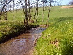
 The Reichenbach near Heimbacher Mühle | |
 | |
| Location | |
| Country | Germany |
| State | Bavaria |
| Reference no. | DE: 247726 |
| Physical characteristics | |
| Source | |
| • location | Confluence of Schützbach and Kirchengrundbach in Reichenbach |
| • coordinates | 50°02′38″N 9°08′24″E / 50.043873°N 9.140099°E |
| Mouth | |
• location | near Mömbris in the Kahl |
• coordinates | 50°03′47″N 9°10′44″E / 50.063136°N 9.178798°E |
| Length | 5.0 km (3.1 mi) [1] (with Schützbach) |
| Basin features | |
| Progression | Kahl→ Main→ Rhine→ North Sea |
The Reichenbach is a left tributary of the Kahl in the northern Spessart in Lower Franconia, Bavaria, Germany. It is 5 km (3.1 mi) long and begins at the confluence of Schützbach and Kirchengrundbach in Reichenbach. Near Mömbris the Reichenbach empties in the Kahl.[citation needed]
Together with Westerbach, Sommerkahl and Geiselbach, the Reichenbach is one of the largest tributaries of the Kahl.[citation needed]
Tributaries
[edit]- Schützbach (left headstream)
- Kirchengrundbach (right headstream)
- Steinbach (right)
- Hohlenbach (left)
- Heimbach (left)
See also
[edit]Wikimedia Commons has media related to Reichenbach (Kahl).
References
[edit]- ^ Complete table of the Bavarian Waterbody Register by the Bavarian State Office for the Environment (xls, 10.3 MB)
